Latest Posts:
Greenland – Part 1 – Nuuk & Ilulissat
Wednesday, 24 June 2026
.
Nuuk is the capital and its latitude of 64°11′ N makes it the world’s northernmost capital, just slightly north of Reykjavík, the capital of Iceland, and about 300km further north than Anchorage in Alaska. Its population of 20,000 makes it one of the world’s smaller capital cities although that’s over a third of the total Greenland population of 56,000. Greenlanders are almost 90% indigenous Inuits, most of the rest are Danish.
.
If Nuuk is the capital then Ilulissat is the tourist capital – you visit Ilulissat (once upon a time Jakobshavn) for icebergs. Wikipedia reports that ‘The Ilulissat Icefjord (Ilulissat Kangerlua) is a massive UNESCO World Heritage site in western Greenland. Located 250 km north of the Arctic Circle, it stretches 40 km from the Greenland ice sheet to Disko Bay. It is famed for the Sermeq Kujalleq glacier, one of the fastest and most active in the world.’
.

◄ Not for Sale T-Shirt – I bought this T-shirt in Nuuk, yes Greenlanders are not at all enthusiastic about being taken over by the USA.
.
I flew into and out of Greenland with Icelandair from Reykjavik (Keflavik Airport), arriving in Nuuk and departing from Qaqartoq. There are also flights from Copenhagen and New York, but not year round. Air travel into Greenland has recently featured major changes. Three airports have been built from scratch (Qaqortoq) or extended and improved (Nuuk and Ilulissat). Nuuk is now the main international arrival point and connections between Qaqortoq and Keflavik in Iceland have just started. Previously there were two ex-military airports built by the USA in 1941 for wartime connections to Europe. They offered long runways and stable weather conditions, compared to the often-difficult coastal weather, but were – deliberately – isolated locations and tourists arriving in Greenland then had to take a domestic flight (or helicopter?) to wherever they were going.
.
After WW II Bluie West One became Narsarsuaq and is in the south, not far north of Qaqortoq, but it appears this airport is going to be totally closed. Bluie West Eight or Sondrestrom became Kangerlussuaq and is midway between Nuuk and Ilulissat, but inland. You can walk Greenland’s famed long-distance trek – eight to 10 days to cover about 160km – from Kangerlussuaq to Sisimiut.
.
.
Once you’re in Greenland don’t plan on driving apart from within town limits, there is no road between any of the settlements and towns. My taxi driver out to the airport at Qaqortoq at the end of my visit announced that we were travelling on the longest road in Greenland – 12km from hotel to terminal. If there was a road from Qaqortoq to the northern tip of the island it would be 2500km long.
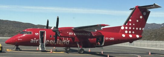
▲ Air Greenland Dash 8
.
.
There are some
ferries around Greenland – the
Sarfaq Ittuk make a once weekly loop between Qaqortoq in the south and Sisimiut or Ilulissat (depending on the season) with 12 stops along the route. Otherwise you can fly and Air Greenland has an extensive – and rather expensive – schedule around the country.
.
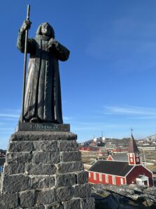
◄ Hans Egede Statue & Church of Our Saviour, Nuuk
.
Norwegian Lutheran Egede arrived in Greenland in 1721 and is credited with founding Godthåb, later renamed Nuuk. He was originally searching for the long lost Norse settlements in Greenland.
.
.
.
.
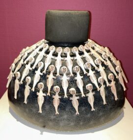
◄ The Nuuk Art Museum is a treat, I could happily make space for some Inuit artwork like Gukki Nuka’s ‘double-necked flask, handbuilt ceramics, cast tupilak figures, 2009. The double-necked flask is inspired by the Greenlandic women’s national garments with glass bead collars. Tupilaks are a mythic Greenlandic creature that a person could use for revenge.’
.
The Art Museum also has a story on Greenlanders getting fed up with constant intrusions on their space (and this was pre-Trump) so let’s raise a Greenlandic Army and turn things around.
.
First we’ll invade Denmark as a try out and then go on to conquer the whole world, it will be a better place for being run from Greenland. A nice little video explains how this would happen – well what do any of those other armed forces know about dog sleds, or kayaks, or hiding behind icebergs? Plus there’s an application form for joining the Greenlandic Army with boxes to tick for what you’ve had experience of shooting: Seal? Reindeer? Hare? Fox? Polar Bear? Whale? Cod? Red Grouse? – OK perhaps Dog? Cat?
.
The Museum also has a town art trail leaflet which I don’t follow very well because it’s in Danish and much of the time I don’t even know what I’m looking for. I definitely do not find Blok P, at one time something of an attraction for its sheer graffiti-covered ugliness. The 1965 plan – like social housing at so many other locations around the world – was to clear people out of slums and into neat, tidy, hygienic apartments. Blok P was low rise but long enough to take 1% of the entire population of Greenland. Inuit would be cleared out of their coastal settlements and moved to this organized new location. Of course it didn’t work that way, people did not want to leave their villages, the Blok P corridors were too narrow to get down wearing cold weather clothing and the closet space was too cramped to accommodate fishing gear. From Day 1 nobody liked it and in 2012 it was demolished.
.
The waterfront Nuuk History Museum features an amazing amount of very detailed history from the stone age, through the Viking and Norse arrivals and the assorted Inuit settlements.
.
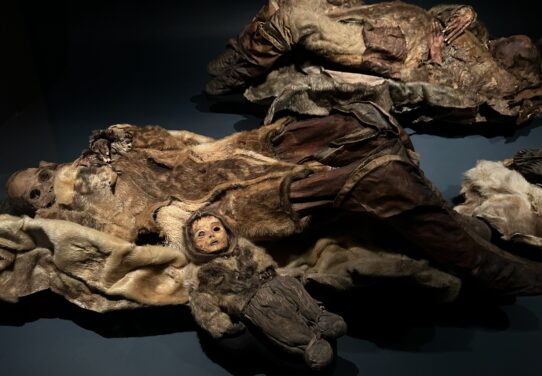
▲ There are a lot of kayaks, but the highlight is definitely the ‘eerily unforgettable,’ as Lonely Planet accurately describes them, 15th century mummies which were found at Qilakitsoq near Uummanna. They’re indeed spooky. There’s also a nearby Nuuk Town Museum.
.

▲
Caffe Pascucci – Nuuk has an assortment of places to eat, I particularly liked this pleasantly busy café. Or try
Iggu for a surprisingly good pizza.
Nivi is fairly flash for Nuuk and does Greenland tapas, ie lots of little dishes which for me includes a musk-oxen slider. Places to drink include the top floor
Skyline Bar in the
Hans Egede Hotel where I stayed.
.
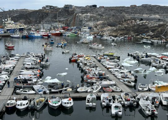
▲ Boat harbour Ilulissat – I quickly come to the impression that Ilulissat is a boys-of-the-frozen-north junkyard. There are boats everywhere, not just in the still-littered-with-ice harbour, but outside every house there seems to be a boat waiting to head to the water. Are there more boats than people in Ilulissat? Then there’s a litter of junked outboard motors and snowmobiles. Apart from the warmer season car and motorcycle wrecks. It’s just junkyard stuff everywhere.
.
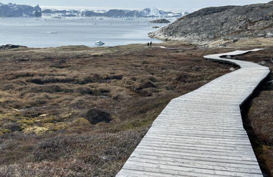
▲ Boardwalk to Sermermiut ruins & Icefjord viewpoint – an Ilulissat plus point is you can quickly get to the Icefjord viewpoint on this boardwalk which also takes you to the sparse ruins of the Sermermiut Inuit village. Once they break off from the glacier it can take up to two years for an iceberg to float down to the sea at Disko Bay.
.
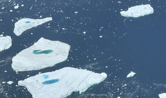
▲ You can also spot icebergs from arriving or departing flights.
.
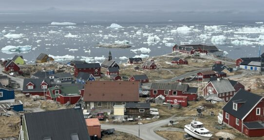
▲ Or from your hotel room, this is the iceberg view from my
Ilulissat Hotel room, the Zion Church right in the centre of my view. I dined in the excellent restaurant at the waterfront
Hvide Falk Hotel with great iceberg views, peel your own Disko Bay shrimps (an awful lot of them) followed by Disko Bay halibut. And a beer, and a glass of Cote du Rhone and a panna cotta to finish.
.
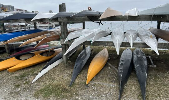
▲ There are no shortage of kayaks in Greenland, lots of them in museums, pinned up on the walls of hotel lobbies or like these clearly in use and stacked up at the waterfront in Nuuk.
.
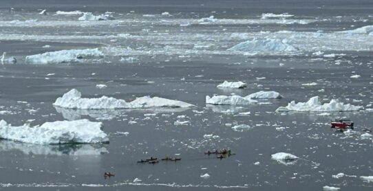
▲ And you can paddle yourself on a kayak tour amongst the icebegs in Ilulissat. I didn’t go out with
Ilulissat Adventure, but when I got slightly lost on first arrival in the town I think it was Kasper Trojlsgaard, the owner, who pointed me in the right direction.
 ▲ Yes dozy Don, also known as Taco Trump, the shambolic President of the USA does have bad intentions for Greenland.