Over the Maldives – fine stonework below (and maybe MH 370)
Sunday, 29 June 2014In a recent posting on Istanbul I commented how on-the-ground reality could run well ahead of our up-to-the-minute internet, with a photograph from the Galata Tower of the Golden Horn, Istanbul’s historic inlet from the Bosphorus. The new (early 2014) Golden Horn Metro Bridge in my photo has yet to show up on Google or Apple maps, although you can find it on Google Earth.
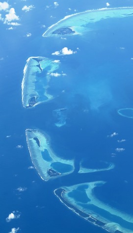
◄ Flying back to Australia on Qantas Flight QF 10 from Dubai to Melbourne we flew right over the Maldives. As usual nobody (apart from on the flight deck I hope!) seemed to be looking, but here’s the view of Dhaalu Atoll, looking south, since I was on the right (starboard) side of the A380.
The bigger island at the top is Kudahuvadhoo, then there’s a group of three islands (Niyama is the middle one, Maaenboodhoo is the larger island at the bottom of the group, ie to the north), then another group of three islands (one of them very small, Vaanee is the larger one to the bottom) and a longer island (Kandimas) leading out of the photo.
Thor Heyerdahl, the Norwegian explorer (think Kon Tiki) visited Kudahuvadhoo in the early 1980s and commented on the amazing stonework on the island’s mosque, recycled from a much earlier structure on the island. He was amazed to find such fine work – better than the Inca stonework in Peru he insisted – on this remote Indian Ocean island. Much more recently islanders on Kudahuvadhoo claimed they might have seen the missing Malaysian flight MH 370 flying low overhead about the time it was supposed to have ditched. Well conspiracy theorists have claimed the US has the aircraft at Diego Garcia, further to the south.
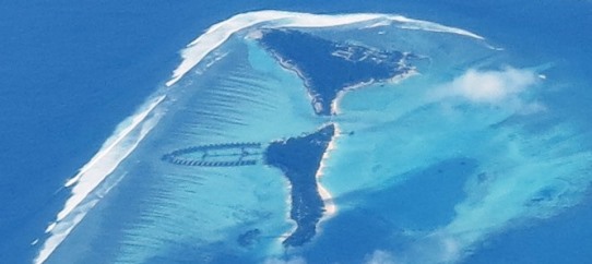 ▲ When I enlarged the photo – taken with my Canon G10, so no big deal photo- graphically speaking – you could make out the overwater bungalows of the Niyama Maldives Resort pointing like an arrowhead eastward from Niyama island. Don’t look for them on Google Earth, the resort opened in 2012 and the Google Earth satellite passed over in 2011. You can find individual palm trees on Niyama, but don’t look for anything further north on Kandimas, the Google Earth resolution drops off from the eastern end of Maaenboodhoo.
Look for the Niyama Resort at E 72°56’6”, N 2° 40’48”