Transport:
The Thames Path – the start
Monday, 18 September 2023 It’s a British National Trail, the only one to follow a river and definitely a river worth following. From its source west of Oxford it runs for 184 miles (294km) through the Cotswolds, to Oxford and on past iconic English names like Abingdon and Windsor and then through the heart of London, finally finishing at the Thames Barrage on the east side of London.
.
◄ The Thames Path can be confusing, because there are many other walking paths available. You need to be careful that you are actually following the Thames Path, a National Trail with its iconic acorn logo. This track marker was only a short distance south of the source.
.
.
.
.
.
.
From my home in London I’ve walked sections of the final stretch of the track – if you’re heading east towards the sea – the final sections are really two walks because there are alternatives on both sides of the river. I’ve also taken trains west out of London and then walked back towards the city. I’ve probably covered about 50km of the lower stretches of the Thames Path. Which is how many people walk the track, they don’t set out from the source and walk eastwards to the sea, or vice versa. Gradually they put the whole walk together on day-by-day walks.
.
 This time I set out to walk the first 90-odd-km of the path, starting from the source and walking downstream as far as Oxford. From central London I took the one hour train trip from Paddington Station to Swindon where I switched trains for the final 12 minutes to Kemble.
.
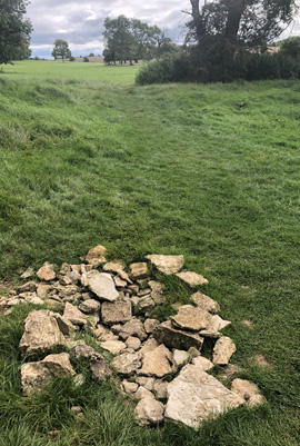
◄ From where it’s only a km or two to the actual source of the Thames. This tumble of rocks marks the spring where the Thames starts although in summer there’s unlikely to be any water appearing. From here it’s all downhill.
.
 ▲ Jenner Hall (Cricklade Parish Hall) & Town Cross, Cricklade
.
After lunch – bought at Pret a Manger back at Paddington Station – it was a 12mile (20km) stroll to my first stop at Cricklade, plus my walk from Kemble Station to the source. The fine late 12th-century St Sampson’s Church with its four-pointed tower is a prominent marker as you approach the town, then seems to disappear once you’re actually there. The church’s four-pointed tower features a later added flying buttress to stop the tower leaning. I like the leather-worker sheers symbol on the tower, but the church is not open so I can’t look inside. The back of Jenner Hall, now the Parish Hall, looks out on the church yard along with a 14th century Town High Cross. Until 1818 it used to stand at the High St cross roads, I would have seen it from my tiny hotel room in The Vale. Then it was shifted because it got in the way of the traffic. Along High St there is also the interesting St Mary’s Church although that isn’t open either.
.
On Sunday night none of the pubs are serving food so I opt for a chicken tikka biryani in Kavali, add a glass of red and it’s £25, all good. I finish up with a Magnum from Tesco and another glass of red back at The Vale. On Monday morning it’s a good job I collected breakfast from Tesco last night as well because there’s nothing open in town. Approaching Castle Eaton I have no success in persuading a cow to shift away from the gate it’s leaning against, I have to squeeze past it.
.
 ▲ The village of Castle Eaton has the neat little St Mary the Virgin Church, dating from the 13the century with a little bell turret which was perched on the roof back in 1860. The village also features a scarecrow trail, featuring a giant king penguin, a dinosaur, a Father Neptune and even a Ronald McDonald.
.
The Thames Path used to march right alongside the busy A361 road, but a new route bypasses it, then rejoins the original route in time for the very old and rather small church of St John the Baptist in Inglesham. Lechlade is the first Thames boating centre where I stop for a quick lunch at the Tea Chest. I’d discarded the Riverside Pub, too big (food wise), too slow I suspect and a shocking write up from Tom Chesshyre in his Thames Path book From Source to Sea. Just before Lechlade I note a narrow boat named Peggy Sue, which gets me on a Buddy Holly diversion of course, singing True Love Ways to myself.
.
 ▲ Then there’s a series of locks, starting with St John’s Lock with the Father Thames statue. For a spell it was installed by the source of the Thames, from here there are lots of WW II pillboxes and boats move slowly, I overtake one on foot. By now I am really tiring, ideally I would have stopped at the Plough Inn at Kelmscott, but it was full. Maureen and I visited Kelmscott with its William Morris Arts & Crafts Manor House back in 2013. At Kelmscott the Thames Path sign announces four miles to Tadpole Bridge, just 1-1/2 circuits of the Tan Track in Melbourne, I reduce all walking distances to Tan Track multiples, but I don’t need any further to walk today.
.
 ▲ First there’s Radcot which has two bridges, the older one, now bypassed by the regular boat route, is the oldest bridge on the Thames, parts of it dating back to the 12th century. Past Rushey Lock, the last lock, I check Google Maps and it’s 11 minutes to go, which is fairly accurate and, amazingly, I walk in to The Trout Inn at Tadpole Bridge right on 5pm, pretty much what I’d hoped for in a best world situation. I’ve walked just over 22 miles, 36km.
.
 ◄
◄ .
Quite apart from being happy to end today’s walk who wouldn’t want to stay at a place called Tadpole Bridge? Plus the Trout Inn is a very nice place to say, not only a much better room than last night in Cricklade it’s also cheaper at £84 versus £90. I get into my very pleasant room and almost immediately crash out. When I wake up (I still had enough sense to set the alarm on my phone) I’m so stiff I can hardly totter to the shower and then to the bar and get that much needed beer. And I’ve got a blister on one foot?
.
 ▲ Tadpole Bridge
.
A salmon burger with fries, a pannacotta, a glass of Côtes du Rhône and later another of Malbec and I feel much happier. Out in the real world there’s air travel chaos in Britain due to an air traffic control meltdown, Maureen was very lucky to get to Belfast just before it all went pear shaped. Setting out next morning I almost immediately encounter a comprehensively squashed dead hedgehog on the bridge back across the Thames. Well there’s a sad start to the day. The track starts along the river, keeping very close at first. There’s another lock, more meadows and the Tenfoot Bridge before I reach Newbridge. I’ve passed the Hart’s Weir Footbridge, which effectively runs from nowhere to nowhere, before I reach the Northmoor Lock, but beyond Bablock Hythe there’s a long dull stretch where the track retreats from the river.
.
 ▲ When the track returns to the river I encounter an amusing stand-off between a couple of swans and an assortment of cygnets (there have been lots of cygnets along the river) confronting a sheep. The sheep is getting too close for comfort, the swans hiss and complain and flap their wings threateningly, but the sheep simply ignores them. It’s as if it has no idea that it’s encroaching on their space.
.
I’m sort of pushing along because there’s nowhere worthwhile to stop for the night before I get all the way to Oxford. Swinford, with another nice bridge, comes and goes, then it’s Wytham Great Wood off to the right, the terrain has been so flat this wooded hill, low though it is, is rather strange. Finally the Thames Path dives under the A34 Oxford Ring Road or Oxford bypass, and I make the short sidetrack to The Trout. Well this is ‘trout to trout’ I comment to the bartender as I order a pint of lime & soda at 5pm. I absolutely need this – liquid and sugar, following Tom Chesshyre’s advice. At which point it actually starts to rain, but soon stops, so past the remains of Godstow Abbey, The Trout was the abbey’s hospice back in 1138, and on into Oxford, but what to do? Ideally I’d have stopped somewhere 10km or so earlier and continued in to Oxford tomorrow morning. I’ve walked another 19 miles, 30km, and I could stop the night in Oxford and do a short walk from the town in the morning. Next time I decide and head to the train station, an hour later I’m back in London after my 50+ mile walk. My train out from London was jam-packed, this one is pleasantly uncrowded.
.
 ▲ The word for the Thames is certainly ‘no.’ The Thames Path and the river features an almost non-stop procession of unwelcoming ‘no’ signs – no parking (cars, bicycles, boats), no entry, no fishing (particularly no fishing), private property, no public right of way, no landing, it’s just ‘no no no.’ I even encountered one ‘Beware of the Bull’ sign at the entry to one field.
